As housing costs climb in popular metropolitan areas, the idea of moving to a far-reaching suburb where housing costs are lower is appealing to many. But as the cost of gasoline rises, so do transportation costs, especially in areas not served by public transportation. Do you know how much you pay for transportation?
A new tool to calculate housing and transportation costs was unveiled this week in Washington D.C., by the U.S. Department of Housing and Urban Development and the Department of Transportation as part of the Partnership for Sustainable Communities.
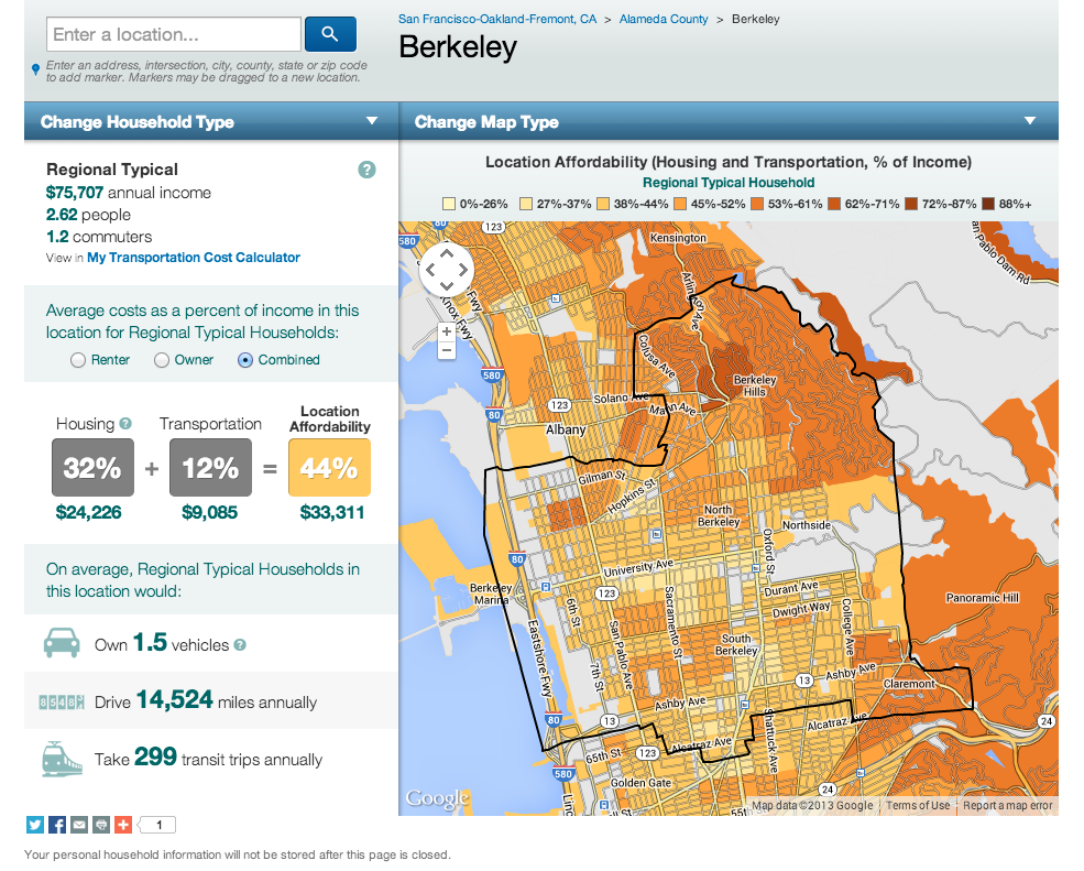
The Location Affordability Portal is made up of two different tools: the map-based Location Affordability Index, which predicts annual housing and transportation costs across the country for various neighborhoods and household profiles, and My Transportation Cost Calculator, a tool that allows users to customize data for their household and potential residential locations. Homebuyers and renters can estimate the cost of housing and transportation for a specific city, neighborhood, or even street to better understand how their transportation options impact their total cost of living.
“Many consumers make the mistake of thinking they can afford to live in a certain neighborhood or region just because they can afford the rent or mortgage payment. Housing affordability encompasses much more than that,” said HUD Secretary Shaun Donovan in a press statement. “The combined cost of housing and transportation consumes close to half of a working family’s monthly budget, and the LAP will help to better inform consumers, help them save money, and provide them with a broader perspective of their housing and transportation options.”
The data presented in the Location Affordability Index shows that how communities are built and connected to each other influence regional transportation costs and vehicle miles traveled. Street connectivity, residential density, and access to transit and jobs all impact household transportation costs. Areas of suburban sprawl generally have higher transportation costs—not only putting a dent in a family’s monthly budget, but also affecting their quality of life and environmental impact. Areas of higher density, mixed-use development have lower transportation costs and also provide access to a healthy walkable lifestyle. “Now, hardworking families all across the country can make better informed decisions about where to live and work, including how their different transportation options may impact those choices,” U.S. Transportation Secretary Anthony Foxx.
Like this article? How about these: